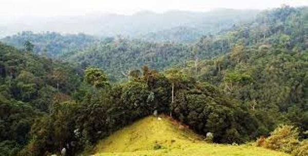
Kigali:The Rwanda Development Board (RDB) has today taken over the management of Gishwati-Mukura National Park. Previously, the park was managed by the Ministry of Environment.
Gishwati-Mukura National Park was formed by the law Nº. 45/2015 of 15 October 2015 and gazetted on 01 February 2016.
RDB has appointed a chief park warden who will be assisted by 25 park rangers. In addition, RDB is working on a multi-phased conservation and tourism management program with Imizi, a subsidiary of Wilderness Safaris, a conservation organization with a presence in seven African countries, to develop and operate an exclusive chimpanzee and primate trekking experience under the Wilderness Safaris brand. RDB will oversee ecology and conservation initiatives including ranger presence, law enforcement, science, engagement of community cooperatives, human-wildlife conflict resolution, research and monitoring.
Speaking during the handover ceremony at the Ministry of Environment in Kigali, Minister Vincent Biruta said:
“Our objective for the Gishwati-Mukura National Park has always been to restore it after it was large parts of it were cleared before and after the 1994 Genocide against the Tutsi through human settlements, agricultural practices and illegal mining among other activities. I commend the efforts so far by different players whose work has led to the status we celebrate today. These partners include NGOs like Association Rwandaise des Ecologistes (ARECO), Albertine Rift Conservation Society (ARCOS) and Forest of Hope. They have all played a significant role and supported the work done by the Government through different programs and projects.”
On her part, the RDB Chief Tourism Officer, Belise Kariza, said:
“This ceremony marks a new step on the conservation agenda of our country. We believe that conservation is not only important to preserve our natural heritage for future generations, but also because of the role it plays in developing tourism as a pillar of the economy. Following the gazetting of Gishwati-Mukura National Park, I am proud to note that 8.9% of Rwanda’s national territory is protected as national parks.
We expect this new project in Gishwati-Mukura National Park to offer another unique world-class tourist experience and draw even more visitors in Rwanda. The Gishwati-Mukura National Park chimpanzee and primate trekking experience will be one more great reason to visit Rwanda”.
Background Information
- The increase of the human population in the 20th century led to the human pressures on mountain forests in Rwanda. By 1984, the mountain forest covered less than 7% of Rwanda’s area.
- The remaining forest area is entirely confined to five insular patches (Nyungwe, Cyamudongo, Mukura, Gishwati and Volcanoes National Park) scattered along the Congo Nile Divide and completely surrounded by areas of intensively cultivated croplands.
- The area Gishwati and Mukura natural forests area was protected since colonial time by the Ordinance of Rwanda-Urundi (O.R.U) No 83/Bis/Agri of 12/12/1933 creating forest reserve in Gisenyi. Its borders were set by the “Ordonance du Roi” Nº 52/114 of 25th October 1951 and it was estimated to cover 250,000 hectares. The law was modified by the Presidential decree Nº 494 of 09 October 1981 creating pasture land and Pine plantation of 100 square kilometers inside Gishwati.
- A huge part of Gishwati Forest was cleared after the 1994 Genocide against the Tutsis and cultivated for cultivation and and resettlement leaving, only 600 hectares of the forest, a loss of 99.4%.
- In 1999, different decisions were taken in the framework of protecting the natural environment and wildlife in the Gishwati area. These decisions included the relocation of all self-settled families (in 1999), redistribution of Gishwati range-land (in 2007 and 2008) and evacuation of families living in high risk areas (in 2010) out of Gishwati followed by plantation of forests in high sensitive zone and demarcation and plantation of buffer zone around the remaining Gishwati natural forest.
- The remaining part of the Gishwati Natural Forest was managed by the Great Ape Conservation Project (GACP) from 2007 to 2011. At the end of its term, Forest of Hope Association (FHA) was created to continue the protection activities.
- The other side Mukura natural forest faced the same challenges of deforestation for settlement and pastoralism of returnees after the 1994 Genocide against the Tutsi.
- Different interventions involving the local administrations (Districts), Wildlife Conservation Society (WCS), Association Rwandaise des Ecologistes (ARECO) and Albertine Rift Conservation Society (ARCOS) have worked towards restoration of the remaining part of Mukura Natural Forest.
- Since 2014, the two natural forests, Gishwati and Mukura, and their surrounding area, have been in the process of being restored under the World Bank project Landscape Approach to Forest Restoration and Conservation (LAFREC) administered through the Rwanda Environment Management Authority (REMA).
- The LAFREC project was established to work concurrently in the three major elements of the landscape – rehabilitating forests and biodiversity within the Gishwati and Mukura Forest Reserves, enhancing sustainable land management in the agricultural lands between them, and introducing sylvo-pastoral approaches in the rangelands of the central former Gishwati Reserve.
- These interventions were synergistic, enhancing biological connectivity at the landscape level and have enabled the park to gainstrong potential for global recognition as a UNESCO Biosphere Reserve and longer-term re-orientation of the local economy towards nature-based tourism.
- A nomination file was submitted to UNESCO for Gishwati-Mukura Landscape to be recognized as a Biosphere Reserve.
- The Gishwati-Mukura National Park today is composed of the Gishwati Natural Forest with an area of 1,439.72 hectares and Mukura Natural forest with an area of 1,987.74 hectares and a buffer zone for this National Park covering the surface of 992.48 hectares. (End)